The Foster Kid Who Drew the Hidden World Beneath Every Ocean
When Home Was Wherever the Maps Were
Marie Tharp learned early that the ground beneath your feet wasn't something you could count on. Born in 1920, she spent her childhood moving between foster homes across Michigan and Ohio, carrying little more than her clothes and an unusual fascination with the atlases she'd find in each new household.
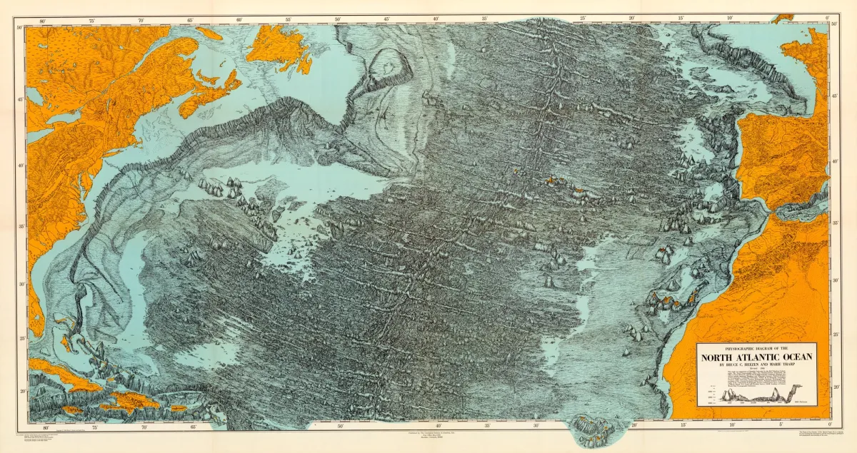 Photo: Marie Tharp, via www.lib.uchicago.edu
While other kids collected dolls or baseball cards, Marie collected maps. She'd trace coastlines with her finger, wondering what lay beneath those blue expanses that covered most of the world. It was a curiosity that would have seemed pointless to most people in 1940s America — after all, the ocean floor was considered as flat and featureless as a parking lot.
Marie didn't know it yet, but she was about to prove the entire scientific establishment wrong.
The Office Where Oceans Came to Life
In 1952, Marie landed a job at Columbia University's Lamont Geological Observatory. It wasn't glamorous work — she was essentially a human calculator, turning sonar readings into hand-drawn charts in a cramped office overlooking the Hudson River. The data came from research vessels she'd never be allowed to board. Women weren't permitted on Navy ships, the official reason being that their presence would be "bad luck."
 Photo: Columbia University's Lamont Geological Observatory, via lamont.columbia.edu
So while her male colleagues sailed the Atlantic, Marie sat at her desk with colored pencils and graph paper, plotting depth measurements that ships had collected by bouncing sound waves off the ocean floor. Each tiny mark represented a piece of the puzzle that was the hidden landscape beneath the waves.
What she began to see in those numbers would change everything.
The Valley That Wasn't Supposed to Exist
As Marie connected thousands of depth measurements across her growing map, a pattern emerged that made no geological sense. Running down the middle of the Atlantic Ocean was a massive underwater mountain range — but stranger still, it had a deep valley running right through its center.
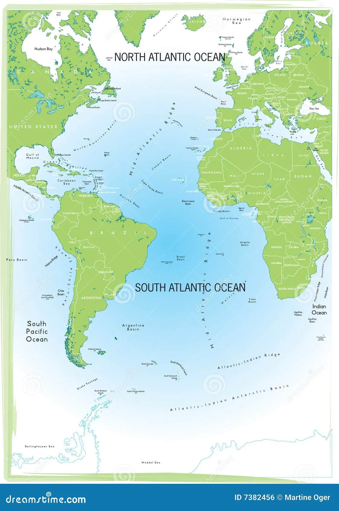 Photo: Atlantic Ocean, via thumbs.dreamstime.com
It was 1952, and the scientific consensus was clear: ocean floors were flat, old, and boring. Continents were fixed in place and always had been. But Marie's map suggested something far more dynamic was happening down there.
She called it a "rift valley" — a crack in the Earth's crust where new ocean floor was being born. If she was right, it meant the Atlantic Ocean was slowly growing wider, pushing Europe and North America apart.
When she showed her findings to her supervisor, Bruce Heezen, he dismissed them as "girl talk."
When Girl Talk Became Gospel
Marie kept mapping. Year after year, she refined her charts, adding detail that revealed an underwater world more dramatic than the Rocky Mountains. Her rift valley wasn't just a local phenomenon — it connected to similar features in other oceans, forming a continuous 40,000-mile mountain chain that wrapped around the planet like the seam on a baseball.
By the late 1950s, even the skeptics couldn't ignore what Marie's maps were showing. The rift valleys were exactly where earthquake activity was concentrated. They lined up perfectly with the edges of what would later be called tectonic plates. Most importantly, they provided the missing mechanism for how continents could drift apart — something scientists had been debating for decades.
Alfred Wegener had proposed continental drift in 1912, but no one could explain how massive landmasses could possibly move. Marie's maps showed the answer: they were riding on ocean floors that were constantly being created and destroyed along these underwater mountain ranges.
The Map That Moved Mountains
In 1977, Marie published her definitive map of the Atlantic Ocean floor. It was a work of art as much as science — a hand-painted masterpiece that revealed the hidden topography of an entire ocean. Mountain ranges, valleys, and plains stretched across the deep in patterns that told the story of how our planet worked.
The map became the foundation for the theory of plate tectonics, which explains everything from earthquakes to the formation of mountain ranges. It's the reason we understand why the Himalayas exist, why California has so many earthquakes, and why identical fossils appear on opposite sides of the Atlantic.
All because a foster kid who never had a permanent home decided to map the most permanent-looking thing on Earth — and discovered it was constantly changing.
The View From the Bottom
Marie Tharp spent her career in the margins — too female for the boys' club of 1950s geology, too focused on the invisible world beneath the waves for mainstream recognition. She worked in a basement office, drew maps by hand when computers were taking over, and studied a place she'd never be allowed to visit.
But sometimes the view from the bottom is the clearest. While her colleagues sailed the surface, Marie saw deeper. While they focused on what was above water, she mapped what mattered more — the 70% of our planet that shapes everything else.
By the time Marie retired, every geology textbook had been rewritten. The "girl talk" had become the foundation of modern earth science. And the foster kid who never had a stable home had given humanity its first true picture of the home we all share.
Today, when scientists study climate change, predict earthquakes, or search for underwater resources, they're building on maps that Marie Tharp drew with colored pencils in a cramped office overlooking the Hudson River. The ground beneath our feet is still moving, just as she showed us. But thanks to her work, we finally understand where it's going.